Upper Colville River, Alaska
| No material from this locality was photographed | Upper Colville Fossil Images Unassigned |
|---|
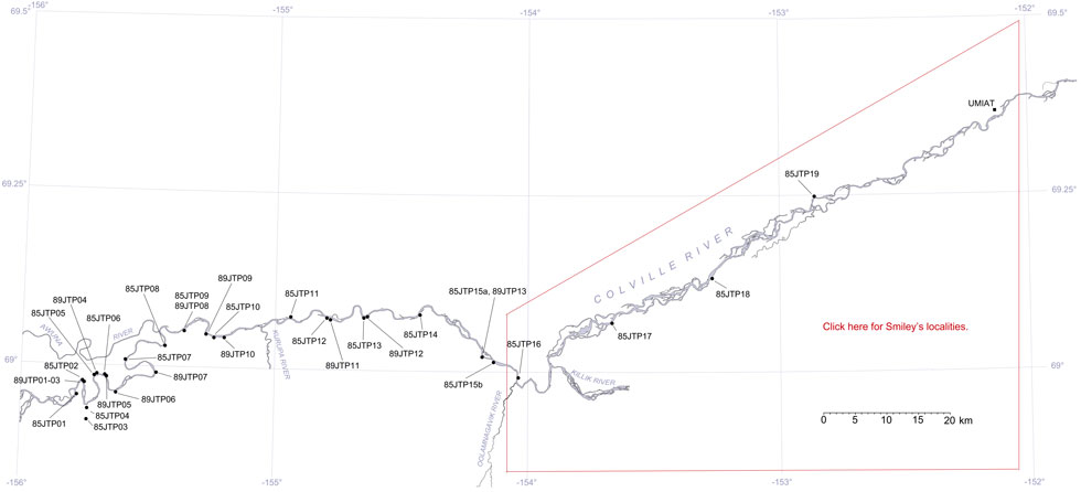
This interactive map of part of the Colville River, Northern Alaska, shows the locations of plant fossil collections made by J.T. Parrish and R.A. Spicer in 1985 and 1989. Click on a number for more details on that site. The red outlined area links to another map showing positions of florules (plant fossil assemblages) collected by C.J. Smiley along both the Colville and Chandler Rivers. |

Locality 85JTP06
This locality is mapped as belonging to KcKt (lower part of the Killik Tongue of the Chandler Formation and Tuktu Formation undifferentiated, Chapman et al., 1964). Mull et al. (2003) reassigned this unit to the middle part of the Nanushuk Formation. However the junction between KcKt and KcK1 (the predominantly non-marine Lower Killik Tongue of the Chandler Formation) is close to this locality.
Although no material from this locality was collected in 1985 fossils were collected in 1989. See locality 89JTP05. The locality is at the downstream end of the predominantly marine 'amphitheatre' section at the marine/non-marine transition. Coal beds in these lower Killik Tongue sediments begin to occur approximately 15 m stratigraphically below demonstrably marine units. Equisetites occurs as float. Generally the abundance of plant material in float increases downstream of the centre of the amphitheatre. The coal seams are generally less than 1 m in thickness and some contain in situ tree bases. The coals are separated by brown to gray siltstones, clays and sandstones. In the upper part of this section mudstones contain numerous Podozamites remains.
The following is a summary of the lithologies in the section as recorded by J.T. Parrish in July 1985.
| Top of section | ||
| 17 m | Sandstone, planar bedded at the base but with large scale load structures in the middle. This represents several rapid depositional events. Intervening fine grained sediment is rare. | |
| 71 m | Interbedded sandstones and mudstones or siltstones | |
| 21 m | Sandstone, siltstones, claystone. Wood fragments present | |
| 0.76 m | Coal | |
| 21.3 m | Claystone with abundant ironstone concretions | |
| 3.8 m | Shaley coal | |
| 4.6 m | Cover | |
| 1.5 m | Fine sandstone | |
| 4 m | Siltstone and coal | |
| 1.8 m | Claystone | |
| 2.4 m | Coal | |
| 9.1 | Fine sandstone with in situ tree bases | |
| 0.6 m | Coal | |
| 12.2 m | Siltstones with abundant ironstones | |
| 3.9 m | Shales containing a 0.3 m thick coal | |
| 13.7 m | Cover | |
| 1.5 m | Siltstone | |
| 5.8 m | Sandstone | |
| 1.5 m | Cover |
