Website Banner


Northeastern Russia

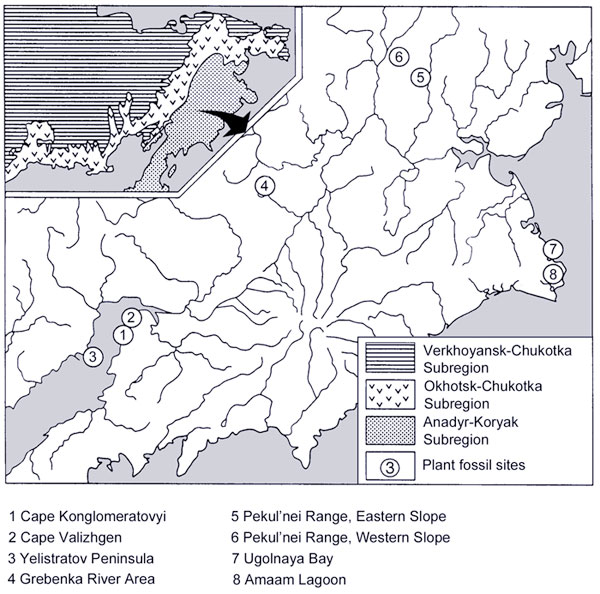
This page is the gateway to a series of pages detailing specific taphofloras. The map is interactive in that clicking on a locality or a name in the legend beneath the map takes you to further information on that site. Some sites may not have active links and when this occurs it means that no further information is currently available.

Northeastern Russia is divided into several subregions based on their geological history. These subregions are:

The Verkhoyansk-Chukotka Subregion (VCSR)

The Okhotsk-Chukotka Subregion (OCSR)

The Anadyr-Koryak Subregon (AKSR)


Interactive map of plant fossil sites in N.E. Russia

Hotspot linking to Amaam Lagoon mapsHotspot linking to  Ugolnaya Bay mapsHotspot linking to  Pekul'nei Range Western Slope mapsHotspot linking to  Pekul'nei Range Eastern Slope mapsHotspot linking to  Grebenka River Area mapsHotspot linking to Cape Yelistratov Peninsula mapsHotspot linking to Cape Valizhgen maps Hotspot linking to Cape Konglomeratovyi maps Hotspot linking to Cape Konglomeratovyi maps Hotspot linking to Cape Valizhgen maps Hotspot linking to Cape Yelistratov Peninsula maps Hotspot linking to  Grebenka River Area maps Hotspot linking to  Pekul'nei Range Eastern Slope maps Hotspot linking to  Pekul'nei Range Western Slope maps Hotspot linking to  Ugolnaya Bay maps Hotspot linking to Amaam Lagoon maps